

With the rise of extreme weather events, hydropower owners and operators are learning how to adapt. According to the Yale School of Environment, climate-related disasters (flooding, landslides, etc.) have jumped more than 83% – from 3,656 events during the 1980 – 1999 period to 6,681 in the past 20 years. The study goes on to discuss how floods have more than doubled, the number of severe storms has risen 40%, and droughts, heatwaves, and wildfires have majorly increased.
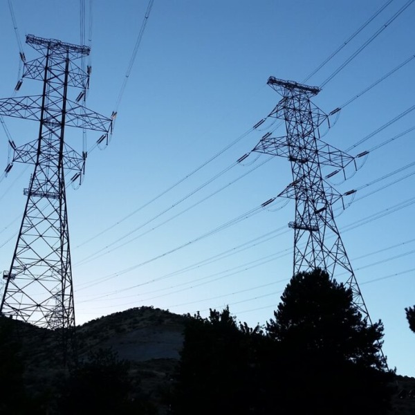
To manage the changing climate, asset owners are turning to more advanced weather and water forecasting technologies to help safeguard projects, increasing resilience to the changing climate.
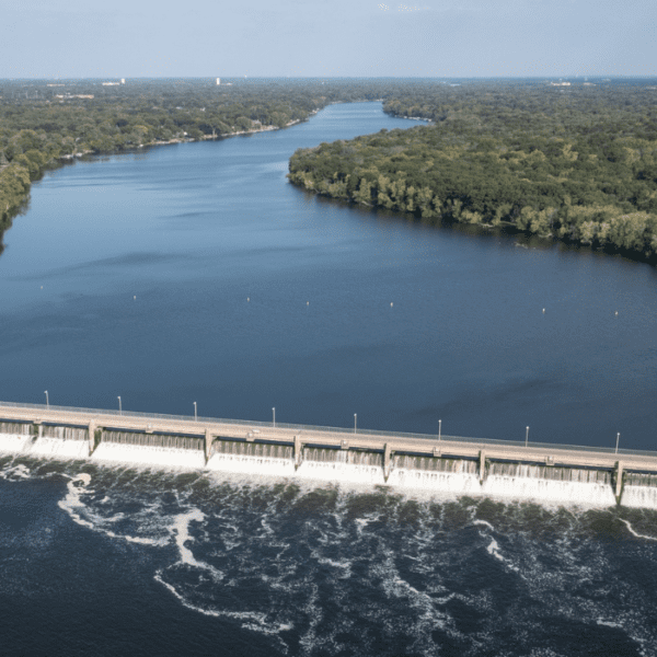
Based in Marysville, California, Yuba Water Agency is an asset owner approaching the ‘new normal’ of extreme weather with a strategy informed by both historical records and technological innovations of the present. For instance, Yuba Water Agency is working with the Scripps’ Center for Western Weather and Water Extremes at UC San Diego and the California Department of Water Resources to develop a deeper understanding of atmospheric rivers, narrow regions in the atmosphere that transport water vapor outside the tropics and cause $1 billion in flood related damages each year in the western United States.
By releasing weather balloons into the atmosphere during stormy winter months, scientists are helping Yuba Water Agency and others analyze how atmospheric rivers contribute to runoff and impact reservoirs. Combined with river streamflow measurements and ground-based weather monitoring stations, the researchers are improving weather models to predict where an atmospheric river will make landfall, as well as the expected intensity and rainfall associated with the storm.
This analysis has led to some important changes for Yuba Water Agency. Not only is the agency adopting a new reservoir management approach called Forecast-Informed Reservoir Operations, they’re also designing an atmospheric river control, or ARC spillway, at New Bullards Bar Dam. The new ARC spillway will significantly reduce flood risk to people, properties, and agriculture along the Yuba and Feather rivers – and potentially as far downstream as Sacramento – by adding additional flexibility to reservoir releases before big storms, as well as by reducing stress on levees throughout the system.
Climate change represents an ongoing challenge to the world, but hydropower asset owners can learn how to mitigate potential damages by developing a deeper understanding of localized weather conditions through modeling and data collection. The information gleaned can then be used to make operational changes and infrastructure improvements to protect investments and communities for years to come.
MARKING 25 YEARS SINCE THE NEW YEAR’S FLOOD OF 1997 IN YUBA COUNTY
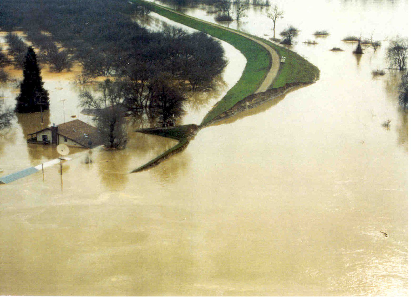
On December 31, 1996, Yuba Water Agency Director Brent Hastey and his wife, Alisan, were enjoying a quiet evening at home with their four young children. Two days later, their family home since the 1850s would be under several feet of water, due to a levee break in Arboga on the east bank of the Feather River in Yuba County.
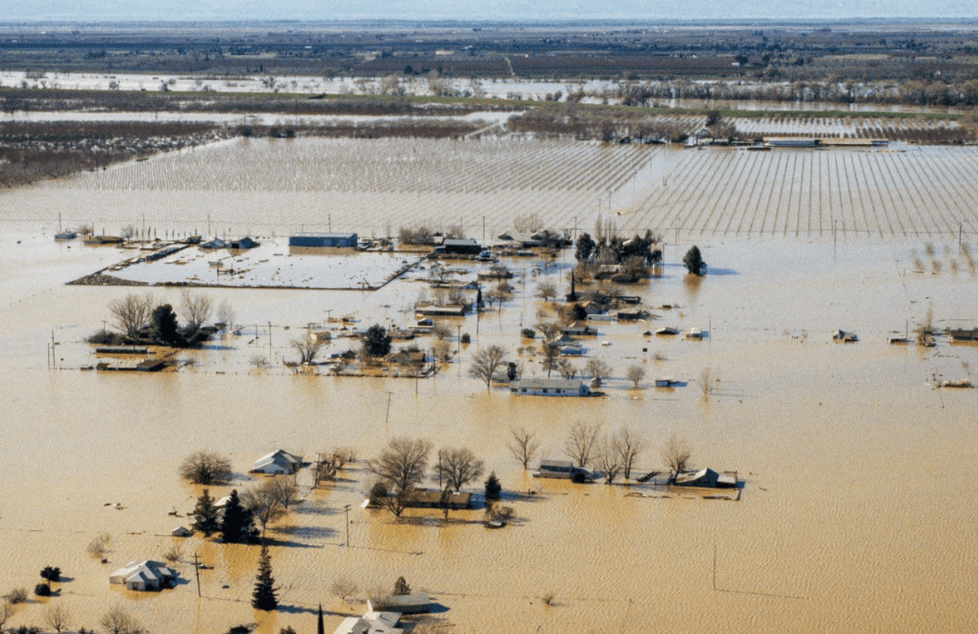
The New Year’s flood of 1997 was the largest in Northern California’s 115-year record in terms of storm intensity and runoff. With damages estimated at $1.8 billion, it was also the costliest. By the end of January, 48 of the state’s 58 counties were declared disaster areas due to high flows and subsequent flooding in nearly all of Northern California’s major rivers.
A view of the east levee of the Feather River breached in Yuba County near Country Club Road.
In Yuba County, floodwaters claimed three lives, destroyed roughly 1,000 homes and resulted in millions of dollars in economic losses. The floods were particularly devastating for the region because many communities and businesses were still recovering from similar flooding in 1986.
Hastey, who at the time was serving on the Yuba County Board of Supervisors, was among the thousands of people impacted by the flood. Following the levee break in Arboga, he recalls returning to his family’s home with a Yuba Water colleague in hopes of retrieving his eyeglasses.
“The only way we could get to my neighborhood was by boat, so we grabbed an agency canoe and started making our way down toward Plumas Arboga Road,” Hastey said. “At first, I thought the house was elevated enough to escape any major water damage. But as we got closer, I was just overwhelmed by the amount of water.”
RENEWED URGENCY FOR LEVEE IMPROVEMENTS AND FLOOD MANAGEMENT COORDINATION
Following the events of January 1997, a Flood Emergency Action Team formed by the governor released a report outlining more than 50 long-term actions and recommendations for improving the state’s flood management practices.
As the local agency tasked with reducing flood risk for the people of Yuba County, Yuba Water had already ramped up its efforts to secure state and federal funding for local projects following flooding in 1986. Working with the U.S. Army Corps of Engineers (Corps), the California Department of Water Resources (DWR), Central Valley Flood Protection Board, Yuba County and others, Yuba Water requested Congressional authorization of the Yuba River Basin Project in 1990.
An aerial view looks west over floodwaters on Murphy Road and Feather River Boulevard within Reclamation District 784 in Yuba County.
Coordinated by Yuba Water and executed through partnerships with the Corps, DWR, Yuba County, the Three Rivers Levee Improvement Authority, local reclamation districts and others, the Yuba River Basin Project has built or improved more than 30 miles of levees along the Yuba, Feather and Bear rivers, including setback levees on the Feather and Bear, and the Marysville Ring Levee. It also replaced key parts of the Western Pacific Interceptor Canal, which conveys stormwater from southern Yuba County into the Bear River.
The Feather River Setback Levee is one of the most significant infrastructure improvements completed as part of the broader Yuba River Basin Project. Completed in 2010, the multi-benefit setback levee improved local and regional flood protection by widening the floodway on either side of the Feather River near Arboga, Linda, Olivehurst and Plumas Lake. The expanded floodway lowers surface water levels during high flows and eliminates areas where water can back up while providing 1,500 acres of riparian floodplain habitat for fish and wildlife.
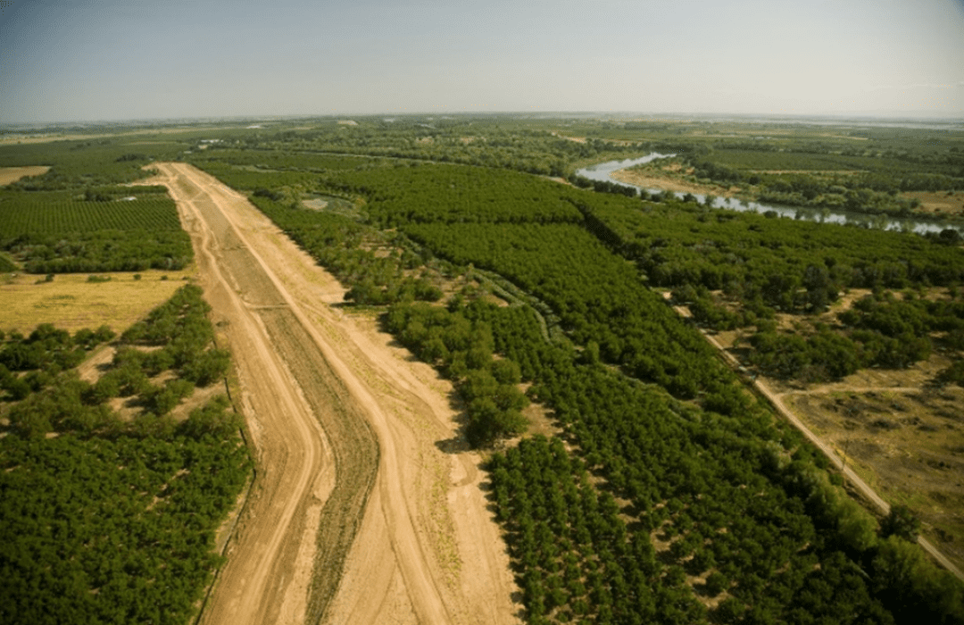
Completed in 2010, the award-winning Feather River Setback Levee is one of the major projects to reduce flood risk in Yuba County and part of the broader Yuba River Basin Project.
Yuba Water’s director of water resources and flood risk reduction, Ryan McNally, who also lived through the 1997 floods, calls the levee improvements completed as part of the Yuba River Basin Project a “game-changer” for Yuba County.
“Not only has the project significantly reduced flood risk and deepened our relationship with local, state and federal partners, it also brings tangible economic benefits to Yuba County residents and businesses,” McNally said. “Having a 200-year-level of protection lowers the cost of flood insurance for families and ensures local development can move forward without additional building or permitting costs required in higher-risk flood zones.”
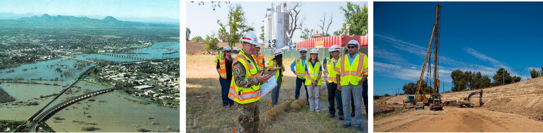
(Left) A photo showing floodwaters from the Feather and Yuba rivers surrounding Marysville in 1997 reinforce the importance of the 7.5-mile-long Marysville Ring Levee that protects the city. Led by the U.S. Army Corps of Engineers (center), reinforcement of the Marysville Ring Levee (right) is slated for completion in 2024.
COORDINATING RESERVOIR OPERATIONS ON THE FEATHER AND YUBA RIVERS
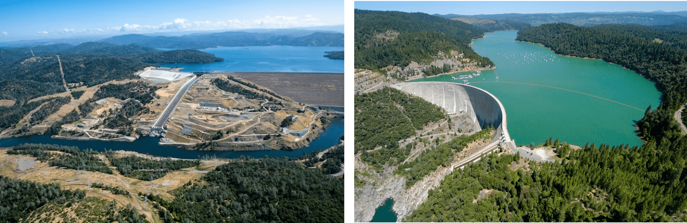
DWR and Yuba Water implemented Forecast Coordinated Operations at Lake Oroville (left) and New Bullards Bar (right) in 2005 to increase coordination and reduce flood risk ahead of storms.
In addition to the state’s Flood Emergency Action Team report, Yuba Water funded several supplementary flood studies that determined the need for more closely coordinated reservoir operations between the Feather and Yuba River watersheds to further reduce flood risk in the region.
Formally launched in 2005, the Forecast-Coordinated Operations (F-CO) program expanded and improved monitoring and information-sharing among federal, state and local agencies in the Yuba-Feather watershed. The program also created common decision-support tools for coordinating water releases from DWR’s Lake Oroville and Yuba Water’s New Bullards Bar Reservoir.
“The greatest benefit of the F-CO program is how it empowers communication between partner agencies,” said Joe Forbis, chief of water management for the U.S. Army Corps of Engineers Sacramento District. “It ensures everyone has the most current reservoir operations plans for Oroville and New Bullards Bar dams, which is critical to being able to operate those projects as efficiently as possible.”
F-CO also laid the foundation for a new, forward-looking forecast and operations methodology called Forecast-Informed Reservoir Operations (FIRO). Led by the Scripps Institution of Oceanography’s Center for Western Weather and Water Extremes (CW3E) at UC San Diego, with partners including Yuba Water, DWR, the Corps and the California Nevada River Forecast Center, the Yuba-Feather FIRO partnership began in 2019.
“DWR’s close partnership with the Yuba Water Agency has succeeded in creating a dynamic model of communication and collaboration,” said Karla Nemeth, director of the Department of Water Resources. “By engaging together with science, academic and governmental partners in the pursuit of emerging forecasting technologies like FIRO, as well as building flood protection improvements and coordinating closely when storms arrive, we are able to reduce flood risks in the Yuba-Feather Basin.”
In addition to investigating FIRO, Yuba Water and DWR are also working with the Corps simultaneously to update the water control manuals for each reservoir. Water control manuals guide water releases for reservoirs like Lake Oroville and New Bullards Bar, which are required to maintain flood storage space during certain times of the year.
“We’re focusing on how the current operations rules in the water control manuals for Oroville and New Bullards Bar dams could achieve new flood risk management objectives for the Yuba-Feather watershed,” Forbis explained. “With partners like CW3E added to the group, we’re not only looking at what potential changes could be made to operations based on current forecasting and modeling skills but how improvements to those skills could be incorporated in the future.”
When implemented together, F-CO and FIRO combine flexible water management operations during potential flood events with improved atmospheric river forecasts. The goal of the Yuba-Feather FIRO partnership is to substantially reduce flood risk by creating more storage in reservoirs ahead of big storms while also ensuring water supply reliability when prolonged dry conditions are forecast. Both benefits also improve the region’s resilience to climate change.
“California’s hydrology is already highly variable, and periods of extreme drought and flood are expected to increase in magnitude and frequency in the future,” explained John James, Yuba Water’s manager of resource planning. “Because FIRO includes more operational flexibility based on the best available science and forecasting, rather than relying primarily on historical hydrologic data, it is an ideal tool to help us manage and adapt to these changes.”
BUILDING UNDERSTANDING OF ATMOSPHERIC RIVERS AND MODERN FLOOD MANAGEMENT
In their coverage of the 1997 flood, Sacramento Bee reporters wrote, “With maddening irregularity, the rivers that define much of Northern California exact a price from those who inhabit their ancient floodplains.”
Today, water managers are better prepared for the “maddening irregularity” of California’s hydrology. Dramatic improvements in weather and river forecasting in the 1990s, including Doppler radar, more complex weather forecast models and expanded use of tools like the California Data Exchange Center made it possible to prepare for precipitation events days in advance, giving water managers more time to release water from reservoirs and prepare for high flows.
“Thanks to expanded monitoring networks, more advanced models and research, we can anticipate storms much further in advance, which adds tremendous capacity to our ability to plan for bigger storms like atmospheric rivers,” said John Leahigh, DWR’s state water project water operation executive manager.
In recent decades, researchers have also deepened their understanding of atmospheric rivers – powerful, rain-heavy storms that cause an average of $1 billion in flood damages each year in the western U.S. Working with the Scripps’ CW3E, Yuba Water and DWR are researching how atmospheric rivers impact snow level variability and runoff. Understanding at what elevations rain turns to snow is especially critical in the Yuba and Feather River watersheds due to their proximity to the Sierra Nevada, where snowmelt can impact runoff during storms.
One of the ways Scripps’ Center for Western Weather and Water Extremes scientists study atmospheric rivers is by launching weather balloons, called radiosondes, during storms throughout the winter months to help build a robust data library on atmospheric rivers. Combined with river streamflow measurements and ground-based weather monitoring stations, researchers are improving weather models to predict where an atmospheric river will likely make landfall and the expected intensity and rainfall associated with the storm.
“The science of forecasting atmospheric rivers has continued to advance, particularly in understanding the origin and evolution of these storms,” said Marty Ralph, CW3E’s director. “These advancements have helped scientists and forecasters to understand critical watershed-scale storm characteristics such as snow level, intensity and duration and can help officials assess flood potential in their jurisdictions before storms strike.”
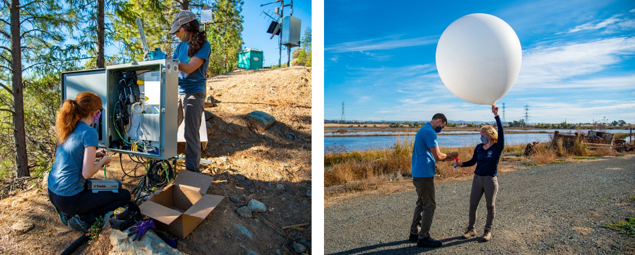
Scripps Institution of Oceanography field researcher, Ava Cooper, and Yuba Water hydrologist, Carly Hecht, conduct maintenance at a weather monitoring station at New Bullards Bar Reservoir (left). John James, Yuba Water’s manager of resource planning, and Scripps’ Kerstin Paulsson launch a weather balloon (right).
FLOOD RISK REDUCTION IN THE 21st CENTURY
In the 25 years since the New Year’s flood of 1997, Yuba Water has worked closely with local, state and federal partners to ensure Yuba County never sees flood damage of that magnitude again.
All told, Yuba Water, DWR, the Corps, local levee and reclamation districts have invested upwards of $600 million to reduce flood risk for Yuba County communities, including through projects like the Feather and Bear River setback levees, the Marysville Ring Levee and other critical infrastructure and coordination. Thanks to these efforts, Yuba County is now among the best-protected urban areas at risk of flooding in the state.
Despite these tremendous investments, the risk of flooding in Yuba County is still present. With climate change driving even more extreme periods of wet and dry, Yuba County’s flood risk will likely increase in the future. But Yuba Water is already preparing for these changes.
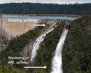
Yuba Water is designing a new atmospheric river control (ARC) spillway at New Bullards Bar, with spillway gates 31.5 feet lower than the existing spillway gates, allowing for the release of 35,000 cubic feet of water per second in advance of large, threatening storm events, when there is enough downstream channel capacity to handle the flows.
In one of its most significant infrastructure initiatives since building New Bullards Bar Dam and Reservoir in the 1960s, Yuba Water is designing an atmospheric river control, or ARC spillway, at the dam.
The new ARC spillway will significantly reduce flood risk to people, properties and agriculture along the Yuba and Feather rivers – and potentially as far downstream as Sacramento – by adding more flexibility to reservoir releases before big storms and by reducing stress on levees throughout the system. In Marysville, the added flexibility of the ARC spillway is expected to reduce the water level on levees by up to two feet during a storm event like 1997.
“The ARC spillway is being designed with gates 31.5 feet lower than the dam’s existing spillway gates, which means we can release water in advance of large storm events when there is enough downstream channel capacity to handle the flows,” James said. “Combined with the implementation of FIRO and an updated water control manual for New Bullards Bar, the project will significantly improve public safety in the region.”
Yuba Water is working with a team of engineers to bring the ARC spillway project to a 90 percent design phase by 2022 and is exploring potential partners to collaborate with for this important multi-benefit project.
Reflecting on the 1997 New Year’s flood and where Yuba County is today, Director Hastey says he’s grateful for Yuba Water’s ability to collaborate and advocate for the people of Yuba County.
“I don’t think anyone could have imagined that a small, disadvantaged community could put the kind of flood safety measures in place that the agency has,” Hastey said.
“From building New Bullards Bar, to putting half a billion dollars into a levee system that is now the best in the state, and now, collaborating with the best and the brightest on FIRO and a second spillway at the dam, we are a community that continues to do everything we can to protect our citizens from flooding and make their lives better.”